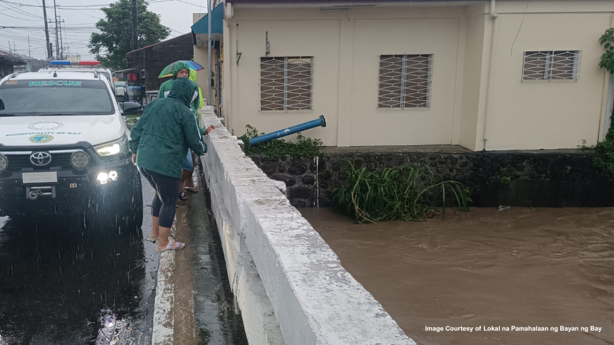
BAYWATCH – Building a Proactive Flood Risk Assessment and Early Warning System in Bay, Laguna
By IMPACT R&D
Bay, Laguna, Region IV-A, Philippines
Donors
13 DonationsNetken Mendoza
Jan 29, 2026, 03:28 PM
₱1,000
2XeU...7mjRoel Fucio
Dec 17, 2025, 04:01 AM
₱500
Svpr...U6BMitsui Chin Sen A. Yu
Dec 17, 2025, 03:51 AM
₱100
3fF7...DtPjustine santos
Dec 15, 2025, 06:42 PM
₱100
4gaZ...wckjustine santos
Dec 15, 2025, 06:30 PM
₱100
5YPZ...iUyAbout This Project
Ask the Scientists
What is the context of this research?
What is the significance of this project?
What are the goals of the project?
Budget
Note: Fund transfers will be made once the required amount for a given component or objective has been met. This setup allows us to keep our budgeting flexible and ensures that funds can be allocated where they are most needed.
- Office supplies, communication, utilities – ₱50,000
- Contingency fund – ₱50,000
WebGIS Portal & Visualization Tools
- Development of the web‑based GIS interface and dashboards - ₱250,000
- Real‑time data integration & visualization - ₱200,000
Data Repository & Reporting Modules
- Construction of a database and data‑management backend - ₱100,000
- Development of damage‑reporting tools and post‑event analysis modules - ₱50,000
Multi‑Hazard Alert Protocols & Thresholds
- Design of forecasting protocols for 12‑hour, 24‑hour and multi‑day windows - ₱150,000
- Participatory determination of alert thresholds and trigger points - ₱150,000
EWS Software & Hardware Integration
- Development of alert‑generation algorithms and user interfaces - ₱350,000
- Integration of sensor data, external forecasts and API development - ₱350,000
Guidelines & Replication
- Development of guidelines, best practices and manuals for scaling the model - ₱50,000
- Pilot tests and knowledge transfer to neighboring LGUs and watershed areas - ₱100,000
Project Management & Monitoring/Evaluation
- Project coordination, administrative support and periodic reporting - ₱25,000
- Monitoring and evaluation, final documentation and dissemination - ₱75,000
Sensor Network & Data Acquisition
- Procurement & installation of hydrological, meteorological and soil sensors (rain gauges, water‑level sensors, soil‑moisture sensors) - ₱350,000
- Acquisition of remote‑sensing data (satellite imagery, UAV surveys) - ₱150,000
Baseline Data Compilation & Community Mapping
- Digitization of historical flood/landslide records and hazard data - ₱50,000
- Community mapping and participatory data‑gathering exercises - ₱50,000
Integrated Flood‑and‑Landslide Risk Models
- Hydrologic‑hydraulic simulations under various rainfall and lake‑level scenarios - ₱250,000
- Slope‑stability and geotechnical modeling using machine learning and remote‑sensing inputs - ₱200,000
- Land‑use change and drainage‑capacity analysis - ₱150,000
Hazard Maps & Vulnerability Analysis
- Production of impact‑oriented flood and landslide maps and priority zones - ₱100,000
- Production of impact‑oriented flood and landslide maps and priority zones - ₱100,000
Trained Personnel & Engaged Communities
- Training sessions and simulations for DRR officers, LGU staff and volunteers - ₱300,000
- Community workshops, participatory mapping, citizen‑science activities and feedback loops - ₱200,000
Institutional Partnerships & Knowledge Sharing
- Preparation of memoranda of understanding and collaboration agreements - ₱50,000
- Joint capacity‑building programs with academic institutions, NGOs and private‑sector partners - ₱50,000
Project Timeline
Meet the Team
Dr. Arnan B. Araza
Project Leader
Dr. Pamela Louise Tolentino
Hydrologist And River Science
Iot/remote Sensing Specialist
Community Engagement Officers
LGU Bay
Institutional Partner
Laguna Lake Development Authority
Institutional Partner
Discussion
0 comments